Unlock insights from your data with the power of GIS

Skill up with GIS tools and workflows
Whether you're an individual, a team, or an educational institution, our tailored GIS training programs are designed to meet your unique needs. Choose from scheduled courses, in-person sessions, or custom educational interventions to master the world of geospatial software.
We also develop GIS-related curriculum materials for high school students and individuals who want to upskill. Dive into Free and Open Source Software (FOSSGIS) like QGIS, GeoNode, POstGIS, and GeoServer, and gain the skills to innovate and lead in the geospatial field.
We also develop GIS-related curriculum materials for high school students and individuals who want to upskill. Dive into Free and Open Source Software (FOSSGIS) like QGIS, GeoNode, POstGIS, and GeoServer, and gain the skills to innovate and lead in the geospatial field.

Build a solution
We design, build, and integrate powerful desktop, web, and mobile applications using leading Open Source software like Django, OpenLayers, QGIS, and PostGIS to meet your specific GIS and IT needs.
Our solutions offer geospatial intelligence, data visualisation, and spatial analysis, empowering you with location-based services, structured workflows, and robust business process solutions. Whether you need custom applications or seamless integration with third-party software, we’ve got you covered.
Our solutions offer geospatial intelligence, data visualisation, and spatial analysis, empowering you with location-based services, structured workflows, and robust business process solutions. Whether you need custom applications or seamless integration with third-party software, we’ve got you covered.

Host, deploy, maintain and support your tech
We provide comprehensive deployment, hosting, maintenance, support, and DevOps services for both our solutions and most Open Source GIS applications, whether on-premise or in the cloud. Our expert team is ready to assist with any question or challenges, ensuring your system runs smoothly and efficiently.
With 10 years of industry experience, trust us to deliver seamless, efficient, and reliable GIS operations that meet all your needs and keep your projects on track.
With 10 years of industry experience, trust us to deliver seamless, efficient, and reliable GIS operations that meet all your needs and keep your projects on track.
A Selection of our Projects
Freshwater Biodiversity Information Management System (FBIS)
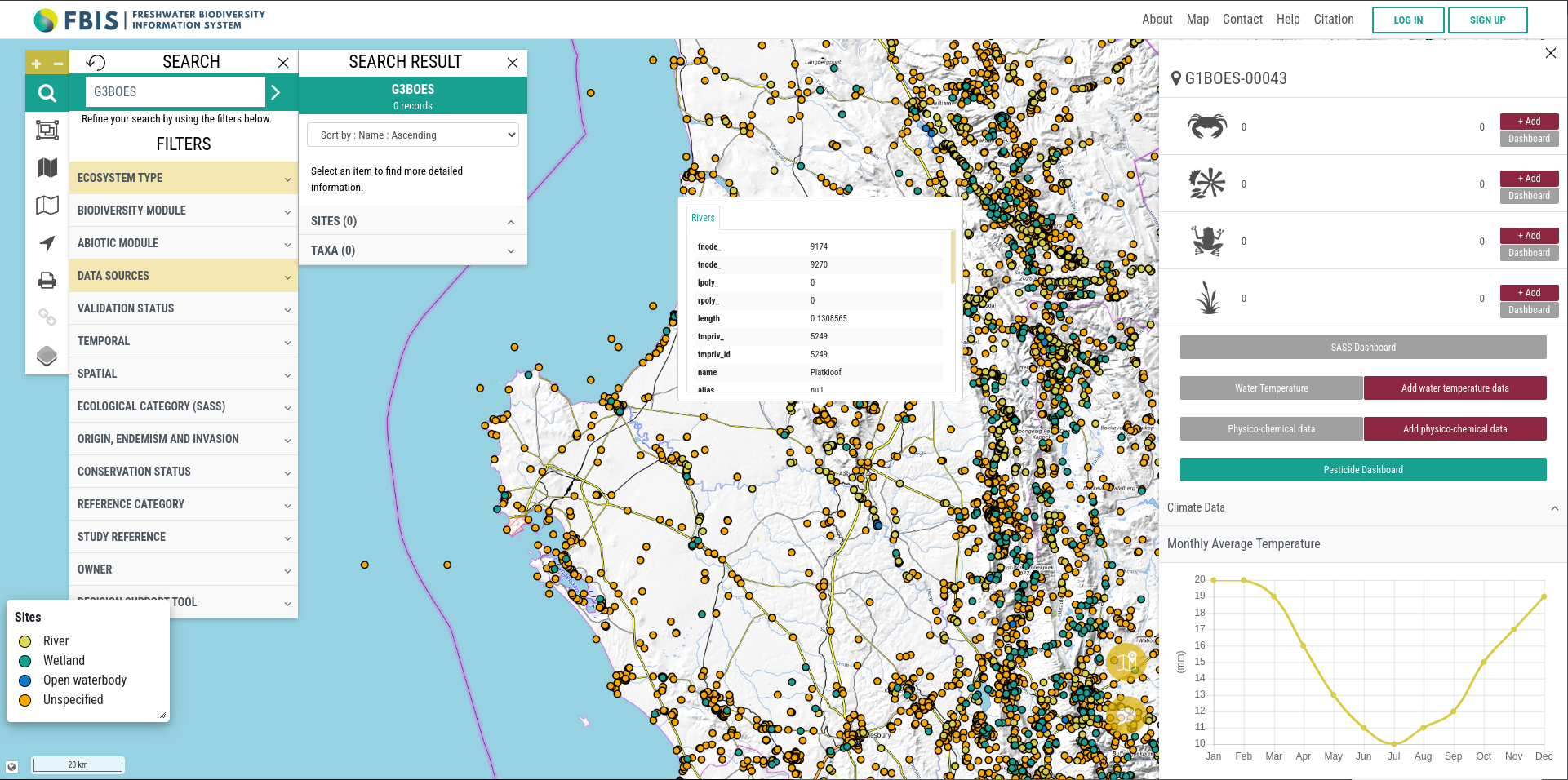
A comprehensive platform developed to host, visualize, and share critical biodiversity data for South African rivers, supporting conservation efforts and resource management across multiple sectors.
InaSAFE Disaster Scenario Contingency Planning Software
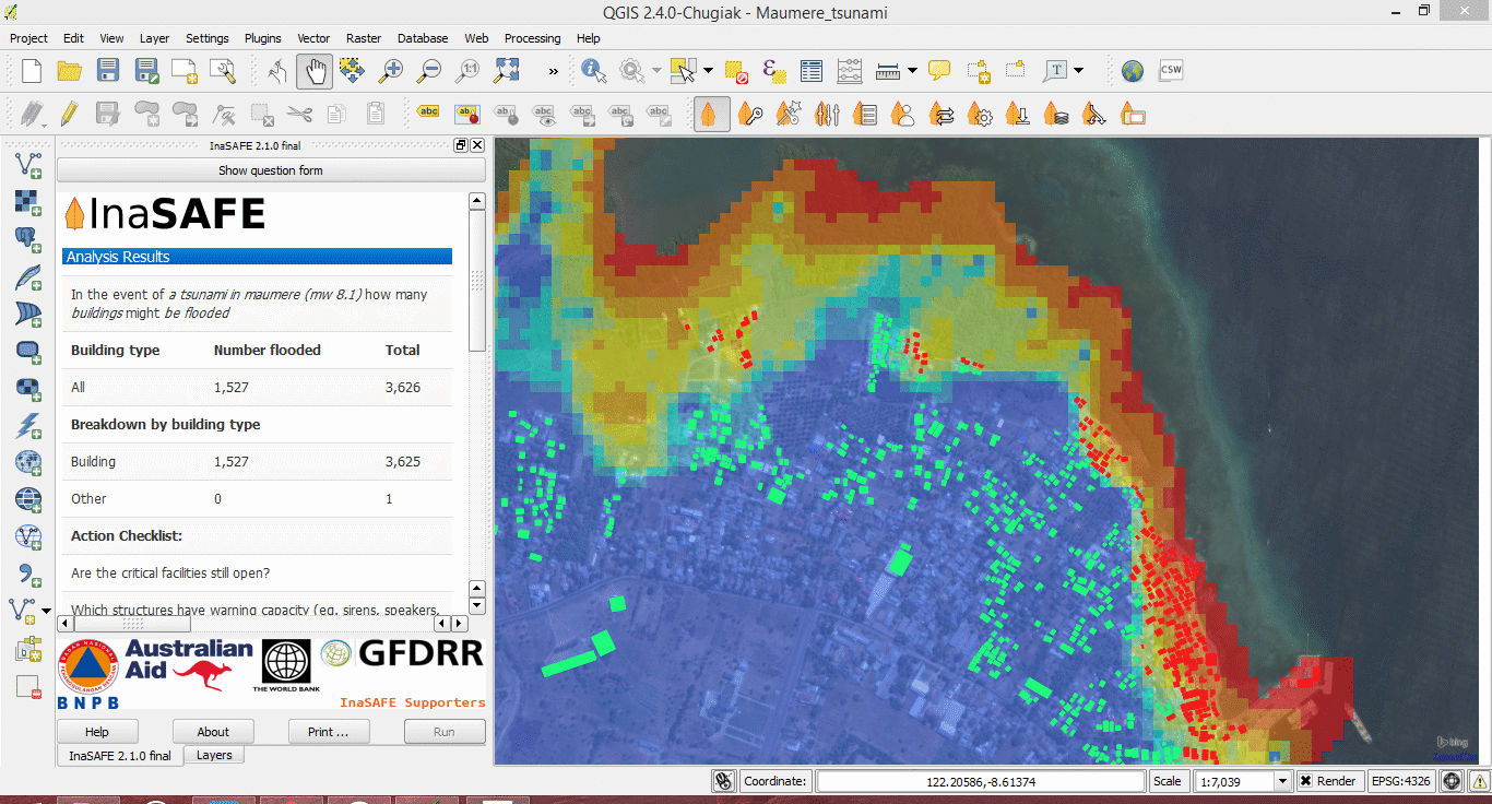
Kartoza and an extended team designed, built and maintained the InaSAFE QGIS plugin and supporting project infrastructure such as the web site and documentation system. InaSAFE is a tool for modelling and planning disaster scenario contingencies for floods, earthquakes, volcanic ash, hurricances and other natural disasters. It was initially developed for Indonesia with Australian funding as an intervention after the 2004 tsunami but can be used anywhere.
MyFarmWeb
An interactive, cloud-based platform for storing, visualising and comparing all types of geographic and IoT agricultural data
QGIS STAC Client Plugin
STAC API Browser is a QGIS plugin that allows the exploration of geospatial data from providers that support the STAC API specification: https://github.com/radiantearth/stac-api-spec
Saint Lucia FOSSGIS Training
Kartoza implemented an Open Source GIS software training programme over the course of 2021 on behalf of the Saint Lucia Disaster Vulnerability Reduction Project in order to improve the internal processes of the Department of Physical Planning and other Domestic Agencies through the use of Open Source Geospatial Applications.
Why Work With Us?
We support Open Source geospatial software
We are an Open Source Geospatial Software
service provider. Choosing Open Source gives
you the freedom to share and modify your system
as your needs grow and change.
Choosing Open Source avoids vendor lock-in.
Our team is available 24/7
Our team works from
various time zones, which means we can provide
professional support at most times of the day, no matter
how complex your query is.
All-in-one development, training and support
We not only develop
and implement software to your precise requirements,
but we can also train your team on how to use the
software, provide support for your system and
offer maintenance and hosting packages.
We’re trusted around the world
Kartoza works with
individuals, companies and organisations across the
globe, including the World Bank, United Nations and government
departments in Australia, Canada and
various African countries.


