Saint Lucia FOSSGIS Training
Kartoza implemented an Open Source GIS software training programme over the course of 2021 on behalf of the Saint Lucia Disaster Vulnerability Reduction Project in order to improve the internal processes of the Department of Physical Planning and other Domestic Agencies through the use of Open Source Geospatial Applications.
Description
The project consisted of a multifaceted approach of providing training, as well as the development and implementation of infrastructure and processes which were handed over to stakeholders with the necessary capacity to continue support and maintenance operations.
Various topics were covered according to specific departmental needs, and delegates proved capable of building tailored solutions that solved real world agency needs as a part of the competency evaluation. These solutions spanned across various domains and included some of the following projects:
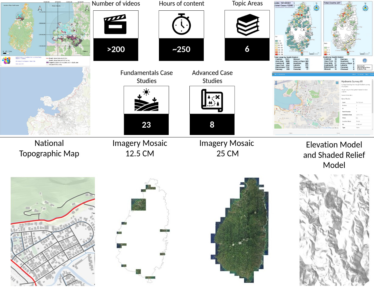
- Highlighting landslide risk on critical water pipeline infrastructure
- Identifying suitable sites for emergency shelters
- Identification of water sources which may pose a risk to increased gastroenteritis related illness
- Regional distribution of COVID-19 Assessment
- Shortest path routing and travel times between firestations
- Property value distributions
- Identification of High Risk Flood Sites
- Integrated desktop and mobile solution for fire hydrant discovery, access, and surveillance
- Field data capture of crime and generation of reports
- Groundtruthing operations for topographic data validation
- Statistics and census map atlas production
By the conclusion of the project, the valedictorian had begun the programme with no GIS experience and went on to attain a new position leading the geospatial capabilities for emergency services on the island.
In addition, a new map service providing a national topographic map service, imagery, and other content of significance was configured and deployed, with a copy of the training materials remanded to The Sir Arthur Lewis Community College for future training programmes.
Various topics were covered according to specific departmental needs, with learning tracks and topics of interest outlined for particular roles within specific agencies. Advanced learning topics included the following:
- Data Visualisation and Dashboarding
- Docker
- GNSS
- PostGIS
- GeoNode Administration & System Administration
- Introduction to Python & PyQGIS
- Spatial Analysis with SQL
- Database Administration with PostgreSQL
- Generating Reports in QGIS
- Metabase
- Advanced Digitizing
- CoGo Plugin
- Cadastral Management and Processing Workflows
- Advanced Cartography
- Mobile Field Data Capture and Mergin Maps
- Intermediate & Advanced Geoprocessing
- Digitization of Historic Data Archives
- InaSAFE
- National Map Production
- Locality and addressing systems
- Beginer to Intermediate OpenDroneMap
- Photogrammetry and Point Clouds
- FOSS Web Map Services
- Mission planning and operational considerations
- Post Processing Survey Data
- Introduction to Remote Sensing
- SALC QGIS Plugin
- BIM and GIS
- Quality Control Procedures
- Version Management
- Quality Assurance Workflows
- Intermediate Raster Analysis
- Permissions Management Workflows
- Survey Officer Workflow
- ETL Pipelines
- Publishing data with GeoServer
- Interaction with Legacy Data Systems
- QGIS Temporal Controller
- Introduction to Networking
- Introduction to Map Servers
- Introduction to Vector Tiles
- Web Map Design
- Application architecture and solution design
- GIS Integrations
Services Provided
- GIS Fundamentals
- QGIS Basics
- Introduction to Spatial Data Infrastructures
- Using GeoNode
- Coverage on various advanced GIS topics
- Provisioning and support of national map services
- Handover of materials to Community College for future capacity building
Completed: 2022-06-01


